SCIENTIFIC RESEARCH / CROPS · SOILS · ENVIRONMENT

Sajad JamshidiPh.D.

Research on crops, soils, and the environment.

RESEARCH SUMMARY

I study how crops respond to soils, water, weather, and management. My work combines field measurements, satellite and UAV observations, process-based models, and machine learning.

Current projects examine plant growth and water stress, soil mapping, model performance in new fields, and the use of crop simulations to compare management options.

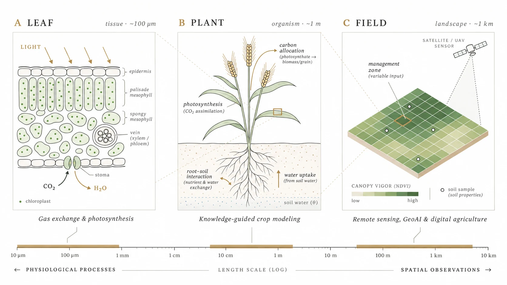
Conceptual scientific diagram connecting leaf photosynthesis and gas exchange, whole-plant processes and crop modeling, and field-scale remote sensing, soil sampling and management zones.
LEAF → PLANT → FIELD / Leaf physiology, crop modeling, and field observations. Conceptual diagram, not measured results.
RESEARCH OVERVIEW   /   00 SWIPE TO EXPLORE THE FIGURE ABOUT & BACKGROUND
Portrait of Sajad Jamshidi
SAJAD JAMSHIDI, PH.D.Photo source: Purdue University ↗

01 ABOUT & BACKGROUND

Research background.

Postdoctoral Researcher · Department of Agronomy, Purdue University

I trained in agricultural engineering and have worked on crop, water, climate, and soil research at Purdue since 2017.

My earlier work examined citrus irrigation and water stress, evapotranspiration, drought, and land–atmosphere interactions. I later studied climate impacts on crop production, rice adaptation, and models of soybean and cotton physiology.

Since October 2025, I have worked with Dr. Siddhartho Paul in Purdue Agronomy on digital soil mapping, sampling design, and remote sensing. I continue to collaborate on crop modeling and plant physiology, and to develop research software for field analysis.

CURRENT APPOINTMENTPurdue University · Agronomy
EDUCATIONPh.D. · Agricultural Engineering (Water Sciences)
02 RESEARCH DIRECTIONS

Current research
areas.

My work focuses on crop and environmental models, remote sensing and spatial prediction, and field-scale simulation.

I / CROP & ENVIRONMENTAL MODELS

Crop and environmental
modeling

I use process-based models to study how crop growth and water use respond to plant traits, soils, weather, and management. I compare model structures, estimate parameters from physiological measurements, and test how machine learning can improve selected parts of these models.

Crop simulationPlant physiologyModel parametersUncertainty analysis
↗
II / REMOTE SENSING & SPATIAL ANALYSIS

Remote sensing &
spatial prediction

I combine soil and field measurements with UAV and satellite imagery to map soil properties, crop conditions, and ground cover. I also test how models perform when applied to different fields, seasons, or sensors, particularly when only a few local observations are available.

Satellite & UAV imageryDigital soil mappingTransfer learningSampling design
↗
III / FIELD-SCALE SIMULATION

Field-scale modeling &
decision tools

I develop tools that combine soil, weather, and satellite data with crop simulations to examine variation within fields. I study when representing this variation changes predicted crop responses or the results of management scenarios, and how to communicate uncertainty in those results.

Crop simulationWithin-field variabilitySoil & waterManagement scenarios
↗

03 SELECTED RESEARCH & SOFTWARE

Research projects
& software.

Selected ongoing studies and software tools. Project and manuscript status is noted for each entry.

01

ONGOING · MANUSCRIPT IN PREPARATION

Minimum Plant Model (MPM)

A process-based plant model of photosynthesis, carbon allocation, and growth, with parameters linked to measurable traits. I developed the first version with Diane Wang and Bryan Runck and am leading the first manuscript.

Process-based models / Trait-based physiology / Python
MODEL DEVELOPMENTRequest details
02

ONGOING · DIGITAL SOIL SCIENCE

Machine learning for field-scale soil and cover mapping

I test whether soil-property models trained in one field can predict conditions in another when local samples are limited. Related work examines how ground, UAV, and satellite images can be used to map residue and ground cover.

CNNs / Satellite & UAV / Sparse sampling
METHODS RESEARCHRelated papers
03

EXPERIMENTAL PLATFORM · ONGOING

Field Crop Twin

An experimental tool that runs crop simulations using field information, weather, and satellite data. It allows users to explore management scenarios through a natural-language interface, with answers linked to model results. I plan to test simulations at different spatial resolutions.

Crop simulation / Field data / Model-grounded AI
RESEARCH SOFTWARERequest details
04

DEPLOYED RESEARCH APPLICATION

GeoSoil Precision

A web application that uses soil and environmental data to evaluate sampling locations, map field variation, and identify management zones. It is deployed on Purdue research-computing infrastructure.

FastAPI / Leaflet / Soil & terrain data
RESEARCH SOFTWARERequest access
05

ONGOING · COLLABORATIVE STUDY

Cotton hydraulics & model–data integration

I use the TREES model and field measurements of gas exchange, leaf water potential, soil water, and canopy temperature to study differences in cotton water use among genotypes. The work includes parameter estimation and uncertainty analysis.

Plant hydraulics / TREES / Parameter inversion
PLANT PHYSIOLOGYRequest details

EARLIER RESEARCH

Previous studies in climate, water, and crops.

2024

U.S. public rice breeding and future climate yield performance

PNAS · collaborative publication
2022

Global processing-tomato production under warming

Nature Food · collaborative publication
2019–21

Citrus water stress, evapotranspiration, and satellite-data fusion

Field measurement & remote sensing

04 PUBLICATION ARCHIVE

Published
research.

41peer-reviewed journal articles in supplied CV
Google Scholar

Publication titles, authors, journals, and years follow the supplied 2026 CV. “Find article” opens a Google Scholar title search rather than an unverified DOI. Manuscripts in preparation or under review are not counted as published articles.

05 ACADEMIC PATH

Academic
appointments.

My appointments at Purdue include work in climate and hydrology, crop modeling and physiology, and digital soil science.

2025—present

Postdoctoral Researcher

Purdue University · Department of Agronomy

Digital soil science / GeoAI
2022—2025

Postdoctoral Researcher

Purdue University · Department of Agronomy

Crop physiology / modeling
2021—2022

Research Associate / Collaborator

Purdue University

Crop / climate modeling
2017—2021

Research Scientist

Purdue University / Indiana State Climate Office

Climate / water / remote sensing

EDUCATION

Ph.D. in Agricultural Engineering (Water Sciences)

Shiraz University · 2022

M.S. · Irrigation & Drainage · 2013

B.S. · Agricultural Engineering · 2009

SELECTED RECOGNITION

2026

First place, IoT4Ag track, Purdue Symposium of Digital Agriculture hackathon — team GEMS

2026

NASA Adaptive Management Opportunity Score (AMOS) proposal submitted — Co-PI (proposal status, not an award)

06 TEACHING & MENTORING

Teaching &
mentoring.

I teach computational methods by starting with the agricultural question, the available data, and the assumptions behind each method.

I have assisted with Weather and Climate, guest lectured in Plants, Data & Computational Thinking and Geospatial Informatics, and mentored students in crop modeling, programming, and geospatial analysis. I emphasize checking assumptions, interpreting results, and explaining uncertainty.

COURSE INTERESTS

Crop Modeling & Digital Twins
Agricultural AI & Machine Learning
Geospatial Machine Learning & Digital Agriculture

These are areas of teaching interest, not claims of courses currently taught as instructor of record.